
FREEPORT – The first floor of the Harrington House, home to the Freeport Historical Society, is all decked out and ready to show and tell a history of transportation in town, from the time the Harraseeket River and horses were the main modes, to when the automobile changed everything.
The historical society holds a grand opening for “You Can Get There from Here – How Transportation Defined Freeport,” from 5-7 p.m. on Thursday, May 15. Visitors will see the culmination of months of volunteer work, including a floor map of the Harraseeket River showing areas where landings, mills, canneries, shipyards and a trolley park developed to connect people to the history of transportation in Freeport.
Another room will feature Freeport village and a floor map showing the major roads that formed the crossroads of travel between inland areas and Porter’s Landing. The map also will show the path of the railroad and of Interstate 295, which divided the town north and south in the late 1950s.
There are life-size cutout photographs of a trolley man and a railroad worker. People can listen to dozens of oral histories from people who remember earlier times. Mike Hewitt of Yarmouth will even drive his 1928 Model A to the Harrington House and park it on the front lawn for display.
“We have three public rooms downstairs, and we’ve laid out the story of rivers, rails and roads in Freeport,” said Christina White, executive director of the historical society. “The stylized map is a way to connect people through the story.”
“You Can Get There from Here” will be open to the public through Feb. 1, 2015.
Rebecca Hotelling collected the oral histories, which other volunteers transcribed and recorded.
“We’re going to put them on a laptop and the voices will tell of their experiences,” White said.
There are many Freeport residents, of course, who still remember the days prior to the construction of I-295, which worried many in the business community because it provided a bypass to U.S. Route 1. No longer would it be necessary for people to get from Brunswick in the north or Yarmouth to the south via Route 1.
“Land was taken by eminent domain,” White said. “It’s had a positive impact on business, but I wouldn’t speak for those who lived through the impact.”
The historical society consulted with John Dority, a former Maine Department of Transportation employee from Freeport, for much of its information on the I-295 project.
“He plays the role of historian within the DOT,” White said, “so he was a great guy to get in contact with.”
Holly Hurd, collections manager for the historical society, wrote a narrative for the entire transportation history exhibit. The coming of I-295, she wrote, changed Freeport in many ways.
“With the coming of the automobile in the early 20th century, motels serving travelers paralleled the 19th century taverns that had provided food for travelers during the days of stagecoach travel,” Hurd wrote. “By the 1950s, the construction of I-295 bisected the town, cutting off a number of range roads and resulting in the destruction and movement of several historic houses. Although this major event solidified Freeport’s place on the path of tourist travel in Maine, a number of citizens recall the hardships the new highway created, and will share their recorded memories of how it affected their lives in town.”
In the beginning, the Harraseeket was the central “highway” of travel. The earliest settlers lived near the coast and on peninsulas, where rivers powered their mills.
“As settlement moved to the interior areas of the town following cessation of the French & Indian Wars around 1760, roads became expedient for inland travel,” Hurd wrote. “At first, the roads that traversed the town and connected Freeport residents were mere pathways cleared through dense woods. These roads were so crude they only enabled travel by horse and rider or ox cart – heavy two-wheeled vehicles pulled by a single horse or hearty ox that could weather travel over very rough, muddy, and stump-ridden paths. As the need for inland travel increased, vehicles improved, as did the surfaces they moved around on.”
“You Can Get There from Here” also will explore how the coming of the railroad in the 19th century solidified Freeport Village, rather than South Freeport, as the center of commerce in town. The exhibit will show how such forms of commerce as quarrying, brickmaking and fishing played roles in where roads and railroads were laid.
L.L. Bean, the town’s magnet store, continues to use the railroad for freight, Hurd said.
Hurd said that a model of Freeport Depot, with railroad cars in front, will be central to the exhibit.
While both passenger and freight service began in 1848, Hurd said, passenger trains ceased operating in town in the late 1950s, not to return until 2012, with the coming of the Amtrak Downeasters.
A CLOSER LOOK
“You Can Get There from Here – How Transportation Defined Freeport,” the new Freeport Historical Society exhibit, opening reception is Thursday, May 15, from 5-7 p.m., at the Harrington House, 45 Main St., Freeport. The exhibit will be open Monday-Friday from 10 a.m.-5 p.m., through Feb.1, 2015. A $3 donation is suggested. For more information, see www.freeporthistoricalsociety.org.
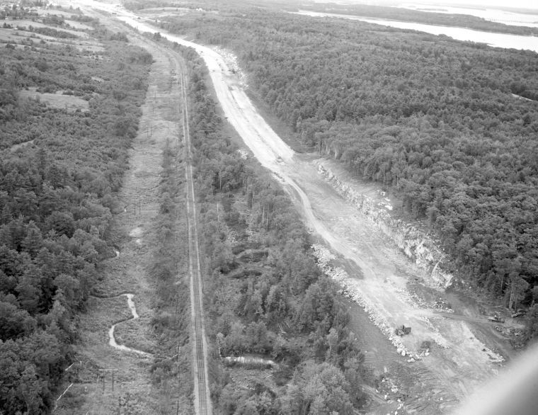 Construction of Interstate 295 in 1958 cut a swath through the wooded areas around Freeport and paralleled Route 1.
 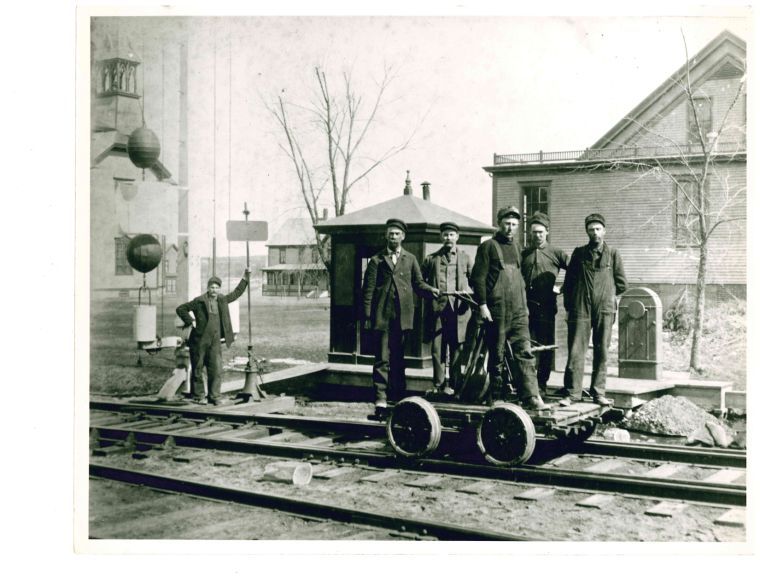 Freeport railroad workers stand on one of the repair carts, around 1905.
 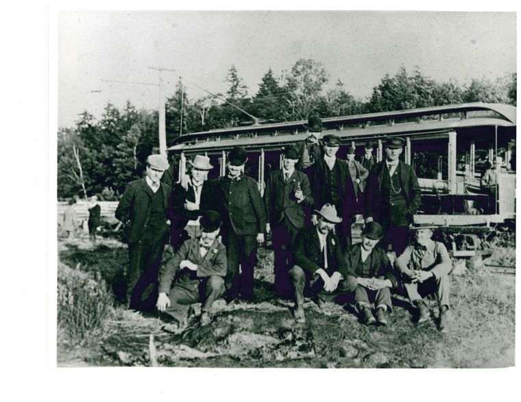 Men who worked on the Freeport trolley stand in front, with passengers in back, in the early 1900s.
 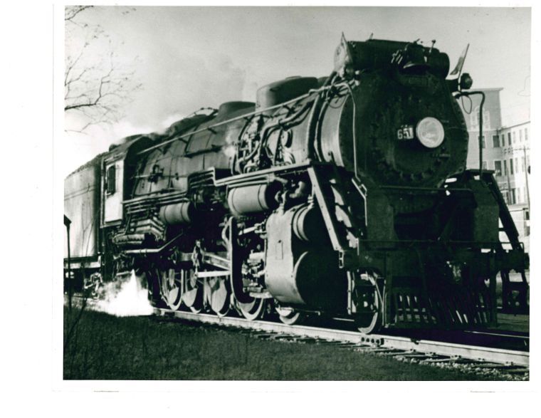 A railroad engine steams by one of Freeport’s shoe factories, probably around the 1920s.
Comments are no longer available on this story