
SOUTH PORTLAND – South Portland City Councilor Gerard Jalbert, who grew up in the Thornton Heights section of the city, has recently taken to calling his old stomping grounds “a neighborhood in decline.”
Bounded by the Rigby Yard railroad bridge to the east and the Scarborough town line to the west, with Interstate 295 an immutable barrier to the north, Thornton Heights is bisected by Route 1, which runs like an asphalt scar down its center.
But by the end of the month, the city will have a report done on how it plans to attack the decline, taking advantage of a sewer project to rebuild Main Street, turning back the clock to a time before it was the only way from Boston to Bangor, at least by land, to an era that predates the automobile-based economy.
According to City Manager Jim Gailey, the intent is to replicate the success of last year’s Ocean Street rebuild in the downtown Knightville district. In recognition of the fact that Route 1 through South Portland is not the thoroughfare it was before the interstate went in, the city will narrow Main Street between Westbrook Street and Mardale Avenue during Phase 1 of a two-year project, widening the sidewalks while adding bike lanes, esplanades, a landscaped center strip and new LED street lamps.
“We’re trying to take a 1960s street and blend it back into the community,” said Gailey. “A new modernized feel goes a long way. It brings a lot of pride back into the area. People then want to not only live in an area, but do business there. As in Knightville, we’re looking for a nice commercial feel, so new development can come back into that area.”
This is now
Jalbert first began to sound the alarm this past April when Jimi’s Trading Center, the city’s first pawn shop in many years, opened its doors.
“There’s the motel with hundreds of units rented as apartments, a payday loan company in the area, and a gas station nearby that sells hard liquor. Now with a pawn shop, it all adds up to a declining neighborhood,” said Jalbert. “It’s not the kind of development I want to see as a city councilor.”
“I would say, absolutely, Councilor Jalbert is onto something,” said Police Chief Ed Googins at the time. “We are daily confronted with calls for service in that area which indicate to us it is in decline. Partly from the transient apartments in that area, what we are seeing is a community in constant conflict.”
According to Googins, his officers were called to the Super 8 motel 68 times last year more than one call per week and that’s a pace the site has kept this year, even with one building recently condemned.
On top of everything else, declining membership has forced the closure of St. John the Evangelist Church. Jalbert, who was baptized and married at St. John, says the final service will be Sept. 11.
In many ways, it seems as though Thornton Heights is starting to more closely resemble its 19th century moniker, when the area was known as “Skunk Hill.”
“It’s sad to say, but it really has seemed like the area is moving in the wrong direction,” said City Councilor Linda Cohen.
“Part of the decline of the neighborhood is that it’s become transient housing for people,” said Jalbert, on Monday.
Those transients are housed in many of the motels that sprung up along Route 1 in the middle of the last century, when Main Street was known as the Saco Road, or the Boston Road, depending on how far you happened to be going. But as Interstate 95, and then its 295 offshoot, were built, diverting most through traffic, the booming motel trade went bust to a large degree. Today, the motels just south of Crockett’s Corner cater in large part to the needy placed in temporary quarters by the city’s General Assistance administrator, and the homeless, under the auspices of Portland-based welfare programs.
But Jalbert, who met with Gailey about the issue again on Tuesday, said motel rooms are serving as long-term solutions to many of the city’s less fortunate.
“What we’ve learned in this study is that there’s a surprising number of people who are staying at the motels who are not on subsidized housing,” said Jalbert. “They’re not receiving vouchers of any kind. It’s like they’re part of the underground economy.”
That was then
Once, the Thornton Heights economy was all above board, and barreling down the main drag as fast is it could go, with gas stations, motels, restaurants and ice cream shops helping it along. But before then, the neighborhood was one of seven distinct villages in South Portland.
Although known as Skunk Hill, Thornton Heights was something of a gentrified affair at the time, being home to Rigby Park, one of the nation’s fastest horse-racing tracks, as well as the Portland Country Club, which set up a 12-hole golf course on the old Thornton Farm in 1897, before decamping to Falmouth in 1915.
Eight years later, the horse track having long since fallen on hard times and closed, Rigby Park became Rigby Yards, home base to the Maine Central Railroad. At one time, the yard employed nearly 1,800 people, fueling residential growth in the area that led to enlargement of Mount Calvary Chapel as a parish of local residents in 1926 and construction of St. John in 1940.
During that era, until the advent of diesel train engines, the defining characteristic of Thornton Heights was the fine grain soot that hung on everything whenever the wind came in from the yards.
Thornton Heights may have its detractors today, but it is also home to many with cherished memories of the neighborhood. In November 2011, more than 50 local residents gathered at City Hall in advance of a yearlong retrospective staged by the South Portland Historical Society. Many recalled the sooty days of their youth.
“I can remember mother would stick her finger up in air only to say, ‘Nope, not hanging clothes today,” said Joseph Nalback Jr., 70, who served 44 years as a volunteer firefighter with Thornton Heights Engine Co. 6.
“Sometimes I had to walk backward with my hands over my eyes, the soot was so thick,” said Harlan Taylor. “My mother was constantly cleaning the window sills.”
But the rail yard was not the only industry in town. According to Barbara Meyers, who met her future husband while working summers at Bennett’s Ice Cream Bar, famed for flavors made from locally grown fruits, area children wiled away the hours watching bottles fly past the giant picture window at the Coca-Cola bottling plant, or Dumpster-diving for spoils at the King Cole potato chip plant.
And, of course, there were neighborhood pharmacies and grocery stores and shops of every description to serve local residents.
“And the storekeeper would deliver, too,” said Kathryn DiPhilippo, executive director of the historical society. “There was a lot of activity in village centers like Thornton Heights, because it just took too long to get anywhere. And, of course, there were local produce and dairy farms that provided most of what anyone could need.
“But the beginning of the loss of the neighborhoods in South Portland was around 1951 when Shaw’s opened, and then in 1955, when the Mill Creek Shopping Center, Maine’s first strip mall, opened,” said DiPhilippo.
Concurrent with that, the city’s first housing development, Sunset Park, went under the hammer. Then, over the next decade, the development of Dyke Farm on Westbrook Street contributed to sprawl.
“People started to get in their cars and go down to the shopping center,” said DiPhilippo.
The change was slow at first. The Kittery-to-Portland leg of Interstate 95 opened in December 1947, and traffic still ran up Route 1 and across the old Vaughn Bridge into Portland. But the economy was changing. Grocery stores and dairy farms gave way to motels and gas stations, the latter then known more by their proprietors A.J. McLean, Stu Brown, Charlie James than their corporate brands. Both car-centric business models did a booming business until the 1970s, when the Interstate 295 exchange went in, siphoning off the cars and making Main Street, as it had been upgraded, all but obsolete.
Back to the future
The city’s water resource protection department is in the planning stages of a sewer separation project that could span two years. As with the $5 million Knightville project, which also took two years to complete, the goal is to stop storm-water runoff from dumping into the sewer system, which can cause effluent to overflow into Casco Bay during heavy rains.
It’s part of a 12-year, $15.6 million plan adopted in December 2011 to eliminate all but one combined sewer discharge point in South Portland, getting rid of the 43 catch basins. When complete, South Portland should be able to comply with its DEP permitting, allowing it to weather the kind of 24-hour rainstorm that has a 50 percent chance of happening in any year, without discharging sewage into the bay, or the Fore River.
The water resource department’s work will be combined with utility updates from Unitil and the Portland Water District to make sure construction crews only have to tear up roads in the area once.
According to Brad Weeks, senior engineer for the water resource protection department, designs done up by Sebago Technics and Alta Planning for how the street might look in the new “Complete Streets” model envisioned by Jalbert and Gailey, should be ready for review by the end of the month.
“We’ve taken the concepts and all the parts they’re looking for and are adding in our parts to determine how it’s all going to work on our end,” Weeks said last week. “We’re pulling all those details together now and, to be honest, it’s all changing on a daily basis.”
A public meeting to review the proposal will be scheduled “sometime in September,” said Weeks. That’s also when a cost estimate will be available for the work, as well as possible sources of grant funding.
“It’s what we can do to revitalize an area,” said Assistant City Manager Jon Jennings, whose specialty is economic development. “We’re not in a position to move business in here. We don’t make that decision. But we can make it an attractive place to be make it more inviting, make it more walkable, make it more green. All we can do is put everything in place to make an area really grow.”
“This concept, with all departments working together off Brad’s project, gives us a chance to address an area that has been quite neglected,” said City Planner Tex Hauser. “If you can get a little bit of a critical mass, maybe people don’t get in their cars and go to get stuff, they walk to the nearest neighborhood activity center.”
But questions remain. Like how will the transient population treat the improvements? Will upgrades just get vandalized before they succeed in luring in new, community-based businesses?
Maybe, but according to those who grew up there, the Golden Age of Thornton Heights always had a little tarnish.
Taylor says he can remember asking his mother for a sandwich to place on the ‘X’ on the sidewalk where McLean Street dead-ended, at a wooded area then known as “Hobo Jungle.”
“There were then what I’d almost call vigilante patrols,” said Bob Dyke, a longtime resident. “You didn’t want to be caught in that neighborhood if you didn’t belong there, especially after dark.”
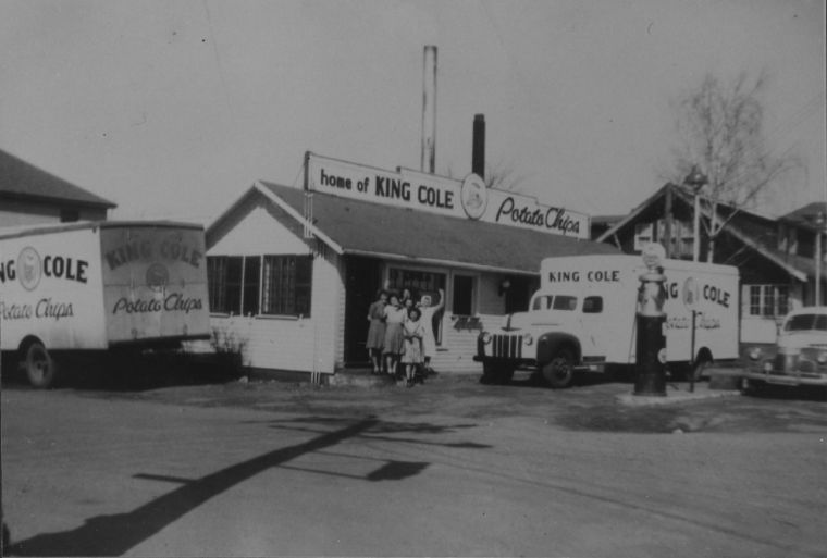 By 1950, King Cole potato chip maker had moved off Main Street for a much larger facility on Cash Street, to be replaced by this Tydol service station in the same building, during an era when the automobile was king and Route 1 was for people passing through Thornton Heights.
  By the time this photo was taken in December 2012, the gas station was gone, replaced by a nondescript office building. South Portland officials now hope to revive the Thornton Heights area by rebuilding the street in ways designed to rekindle the local economy.This photo taken in 1945 at the King Cole Foods potato chip plant at 609 Main St. in South Portland depicts an era when Route 1 through Thornton Heights was rife with local shops serving local residents and local industry, here and at nearby Rigby Yards, providing local jobs.
 Until the 1960s, when the Country Gardens development was built, this area off Westbrook Street in the Thornton Heights neighborhood of South Portland was a hay field for the Dyke farm.
Comments are no longer available on this story