
SCARBOROUGH – For decades, even through the recent recession, Scarborough has had a reputation as a growth community. But now the town is facing another kind of growth that could have a dramatic, even debilitating, effect on the homes and businesses it harbors.
That’s because Scarborough Marsh, a behemoth already at 3,000 acres, is expected to swell 17 percent as sea levels rise through the next century, prompting major changes for human life around the marsh, along with the plant and animal life in it.
“Sea level rise is quickly gaining acceptance as a scientific fact,” said Town Manager Tom Hall, in a recent interview. “It’s not surprising then to learn that areas like the Scarborough Marsh have the ability to absorb much of that rise.”
“The fact is that there are places in Scarborough right now that are not going to be inhabitable 50 years from now,” said Matthew Howe, president of the Friends of Scarborough Marsh, on Tuesday. “We need to figure out how to brace for that inevitability.”
To do that, Howe and representatives from other local conservation groups met Monday at town hall with municipal planners and officials from the Department of Agriculture, Conservation and Forestry. Scarborough is one of a half-dozen towns recently invited to join what the department is calling the “marsh migration team,” and Monday’s meeting was an initial “scoping session” that will lead to a host of community discussions later this summer.
“Principally, this meeting was about getting all the parties together and meeting each other and getting everybody’s expectations and goals for the project out on the table,” said Assistant Town Planner Jay Chace.
Through the next several months, Peter Slovinsky of the Maine Geological Survey will use a $200,000 grant from the National Oceanographic and Atmospheric Administration, obtained by the Maine Coastal Project and its various partners, to map out the impact on the marsh of sea level spikes on the order of 1, 2, and 6 feet, as well as 1 meter (3.3 feet).
Although Slovinsky will calculate all four water levels, a 2010 study prepared by the Saco Bay Sea Level Adaptation Working Group, a joint effort of Scarborough, Biddeford, Old Orchard Beach and Saco, has predicted local sea levels will rise 2 feet in the next 100 years. That is the same standard accepted by the Maine Geological Survey.
Based on that data, Slovinsky already has made some heady predictions.
Last July, he made a presentation to the Town Council on the impact of sea level rise on storm surges along the town’s beachfront communities. At that time, he said adding 2 feet to the normal high tide would inundate 20 homes along historic Higgins Beach during a standard storm. Adding 2 feet to the still-memorable 1978 event, when a local 3.5-foot surge coincided with an astronomical high tide, would flood 95 homes.
At the time, the council was considering and ordinance to increase “freeboard” – the distance between the floorboards of a home and the high-water mark of a 100-year flood – from 1 foot to 3 feet. That would have required any person remodeling a home in any significant way, if the house is in the flood plain, to also jack it up 2 feet.
That plan was put on the back burner when it was realized the Federal Emergency Management Agency was about to come out with new flood maps. Those maps are scheduled for a review session next week at South Portland’s planning and development office, said Hall, prior to public showings this summer.
However, Chace points out the migration team effort is different from the freeboard issue, which will likely return to the council agenda in the fall.
“They’re really two separate projects,” he said. “The FEMA maps look at the extent of today’s flood plain where issues are expected to occur as of this date, for significant events like a 100-year storm. The migration team is look forward, at where the actual mean sea level will be, 25, 50 and 100 years out.”
“Any landowner whose property is abutting the marsh or near the ocean should be paying very close attention to this project,” said Howe.
Founded in 2000, the friends group works to help conserve land around the marsh, and to convince property owners to donate abutting lots to the Department of Inland Fisheries and Wildlife, which manages it. That’s because members are interested in preserving the health of the marsh, but, in the future, they may have to take a more active role in actual cleanup projects, as the marsh encroaches on homes, garages, septic systems and various other household contaminants.
“It will definitely shift our priorities and our strategies,” said Howe.
Chace and Howe agree Slovinsky’s study, along with community input from this summer’s planned series of community meetings, will eventually make its way to the town’s long-range planning committee and any number of future zoning ordinances changes.
“It [the study] will help us plan for the future and ensure that where the marsh wants to go will be in areas that we have already made the wise decision to not develop, or at least where he have begun to plan ahead,” said Howe.
Liz Hertz, who is managing the marsh migration team project for the Department of Agriculture, Conservation and Forestry, could not be reached on for comment.
However, in a solicitation last fall for migration team members, she wrote, “Marshes need room to move inland and upward to survive increased periods of flooding. The natural process of marsh migration is blocked when buildings or hardened structures are located in the uplands next to a marsh. Municipalities, land trusts and coastal property owners can act today to conserve areas that provide room for marshes to move in response to future pressures.
“People and businesses in Maine do not want to lose the flood protection, fish producing and pollution filtering benefits of salt marshes,” she wrote.
In addition to potentially driving some property owners away from land that will eventually be underwater, flora and fauna also may suffer.
According to Chace, a 17 percent growth in the marsh also would transform 80 percent of it into a lowland habitat. Now, about 78 percent of Scarborough Marsh is so-called “high marsh” habitat.
According to NOAA, the elevation difference between these two distinct zones is usually only a few centimeters, but that can make a world of difference. A low marsh floods daily at high tide, while a high marsh usually floods about twice a month during tides that occur in conjunction with new and full moons.
More frequent flooding makes the low areas the saltiest part of a salt marsh, making for a clear delineation between life in the two areas.
According to the NOAA, “plants from one marsh zone are never found in the other.”
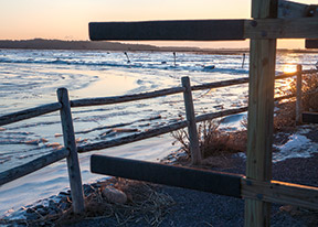 The sun rises over the canoe racks at the closed-for-the-winter Scarborough Marsh Audubon Center.
 Canada geese flee from an early morning intruder in the Scarborough Marsh.
 A bank of off-shore clouds temporarily obscures the rising sun over Scarborough Marsh Monday morning. The marsh could expand 17 percent because of rising sea levels.
 Marsh grass is rimmed by delicate layers of ice at the Scarborough Marsh.
Comments are no longer available on this story