It’s beginning to look a lot like…a snow storm? Fitting to start off December.
More snow is in the forecast for Maine. The overall set up is interesting, bringing plenty of cold air along with moisture over a long period of time. These ingredients all add up to snow
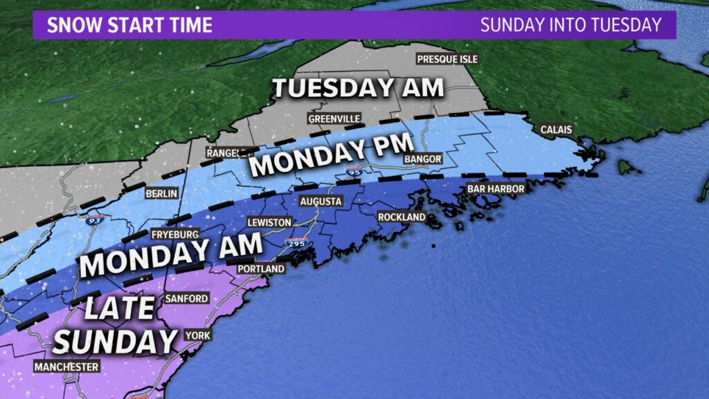
If we’ve got the ingredients, then why is this storm so funky? It all has to do with the storm’s evolution. See the timeline below for a quick glance at how it all shakes out.

On Sunday night, snow starts in southwestern Maine and gradually spreads up the coast toward Portland and inland toward Fryeburg. These flakes stay through the morning on Monday, making things slick for the commute.
While there may be some breaks in the snow activity along the coast Monday, the next coastal low pushes snow back into Maine and it overspreads the state.
Snow will be north of Bangor by Monday evening, with most of Maine seeing snow Tuesday morning. The most widespread impacts for the entire state will be during the morning on Tuesday.

Totals will be highest through southwestern Maine. This is the opposite of what we’ve seen with winter storms so far this cold season.

The bright side to this is that snow is looking less heavy and wet, so power outages should not be a huge issue with this. Most of the concern is going to revolve around travel conditions and slick roads.
To stay informed with the latest weather in Maine, make sure you follow me on Twitter and Facebook. I post regularly, especially when there’s a big weather event coming up.
Comments are not available on this story. Read more about why we allow commenting on some stories and not on others.
We believe it's important to offer commenting on certain stories as a benefit to our readers. At its best, our comments sections can be a productive platform for readers to engage with our journalism, offer thoughts on coverage and issues, and drive conversation in a respectful, solutions-based way. It's a form of open discourse that can be useful to our community, public officials, journalists and others.
We do not enable comments on everything — exceptions include most crime stories, and coverage involving personal tragedy or sensitive issues that invite personal attacks instead of thoughtful discussion.
You can read more here about our commenting policy and terms of use. More information is also found on our FAQs.
Show less