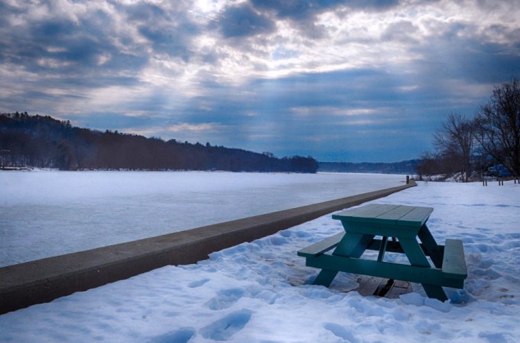
A recent stretch of mild weather has local officials keeping a close eye on the Kennebec River, which is currently covered by flat sheets of ice that could break up after the above-freezing days.
With warm temperatures expected to continue through the weekend and rain showers forecast for late Saturday, the National Weather Service has issued a flood watch for much of Maine from 7 p.m. Friday through Sunday evening.
The combination of warm temperatures and rain could lead ice on the Kennebec River and other waterways to break up and flow downstream, potentially damming up the river, according to Sean Goodwin, director of the Kennebec County Emergency Management Agency.
“Any time you have a lot of broken ice, ice jams are our biggest concern,” Goodwin said. “For the towns of Hallowell, Gardiner, Augusta, Pittston and Randolph, the level of the river can come up 4, 5, 6 feet easily because of the ice jam. Those things concern us.”
The National Weather Service issued the flood watch for Kennebec, Somerset, Androscoggin, Franklin, Oxford and more northern counties of Maine. It also extended the watch to parts of New Hampshire, where the flood risk is greater because of warmer temperatures.
Last month, the ice on the Kennebec River was up to a foot thick in places, but the recent warm temperatures “could have changed that very significantly,” said Margaret Curtis, a meteorologist at the National Weather Service’s station in Gray. A current measure of the ice’s depth was not available.

A flood watch is in effect for the area through the weekend, including the Kennebec River in Hallowell, shown here on Friday.
A half-inch of rain is forecast to fall in the Augusta area over the weekend while three-quarters of an inch could fall farther north, Curtis said. With that rain draining into rivers and raising their water levels, Curtis warned that upward pressure could be placed on the river ice, breaking it apart.
“Our main concern here would be the potential for ice jams,” Curtis said. “All those chunks of ice can get hung up in a curve of the river or at a bridge or maybe in a shallower section… People should be very cautious around waterways, as the ice will be getting thinner.”
Goodwin recalled a flood that formed in downtown Augusta several years ago after ice broke up on the Kennebec River and water levels rose above the banks in about eight minutes. On that occasion, Goodwin said, members of the Augusta Fire Department had to pull a man off the river ice to prevent him from being swept downstream.
An ice jam also caused flooding in the Front Street parking lot of downtown Augusta a year ago.
During the current flood watch, Goodwin said, he has asked emergency responders in area towns and cities to keep an eye on the weather and the state of the river.

This photo taken on Friday shows the Kennebec River in Hallowell, which sometimes floods following snow melt and rain.
To help lower the risk of flooding from ice jams, the U.S. Coast Guard sends ice breaker ships up several Maine rivers. On the Kennebec River, they go upriver as far as Gardiner, but the U.S. Coast Guard is not currently planning to begin those missions until the middle of March, according to Goodwin, who spoke with its members on Friday morning.
An official from the U.S. Coast Guard could not be reached for comment Friday afternoon.
Temperatures in central Maine will dip slightly on Sunday night to around 25 degrees, but they will continue to rise into the 30s and 40s during the day next week, Goodwin said. He hopes those weather patterns will continue, he said, because that would allow the large piles of snow that have accumulated around Maine after recent storms to melt a little each day before refreezing each night.
In terms of flood prevention, the large banks of relatively fresh snow do carry one advantage, Goodwin said: They are capable of absorbing rainfall, preventing it from flowing into local streams and rivers.
Goodwin also mentioned several other inconveniences that can accompany the recent spell of warmer weather. Because many storm drains are covered in ice, lots of snow melt can puddle on the roads, making travel more difficult and causing potholes to become larger.
As snow melts, it can also lead to the creation of ice dams on top of buildings, which can then slide, fall and potentially damage the roof. That recently happened at the Lithgow Public Library, when a large chunk of snow that had frozen solid after the warm weather slid off the roof, ripping out pre-cast concrete pieces and other parts.
Goodwin recommended homeowners either use a rake to remove ice dams from their roofs or hire professionals to safely do the work.
Charles Eichacker — 621-5642
Twitter: @ceichacker
Send questions/comments to the editors.


Comments are no longer available on this story